Touching Israel: A Journey Through Topography and Time
Touch is an incredibly important part of the human learning experience. There is so much that you take in on a daily basis through your sense of touch that gives you information about the world around you. This shouldn’t be new information – after all – if you’re like me, you might have a small burn scar on your hand from when you pulled something out of the oven in haste without a mit. Too hot, that experience says. But it’s not just about teaching us whether something is hot or cold, sharp or bumpy – touch is an essential part of learning, connection and even long-term memory.
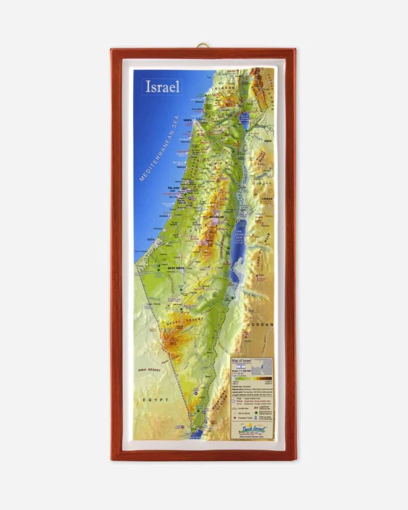
For those who dream of visiting Israel but haven’t yet had the opportunity, there’s now a way to experience the Holy Land’s diverse landscape through your fingertips. The 3D Map of Israel from Israel 365, with its tactile topographical design, offers a unique sensory journey across this ancient and modern wonder.
As your fingers trace the contours of this meticulously crafted 3D map, you’ll feel the rise of Jerusalem’s hills beneath your touch. Close your eyes, and suddenly you’re there – standing atop Mount Scopus, gazing out over the golden city as it sprawls before you, a tapestry of history and modernity intertwined. The bumps and ridges beneath your fingertips tell a story of 2,000 years, each elevation changes a chapter in the land’s rich narrative.
Move northward, and your hand glides over the gentle slopes of the Galilee. Here, you can almost hear the lapping of waves against the shores of the Kinneret (Sea of Galilee), and if you listen closely, you’ll hear the whisper of a breeze through ancient olive groves. The topography speaks of fertile lands that have nourished civilizations for thousands of years, from the time of the Bible to the thriving agricultural communities of today.
Venture south, and the map’s surface changes dramatically. The smooth expanse of the Negev Desert unfolds beneath your touch, punctuated by the occasional rise of a crater rim or ancient trade route. As your fingers explore, you might imagine the caravans that once traversed these arid expanses or picture the modern marvels of desert agriculture that have made the wilderness bloom.
But this map isn’t just about natural wonders. It’s a testament to human ingenuity and perseverance. Feel the narrow corridor of the coastal plain, home to bustling metropolises like Tel Aviv. Here, your imagination can conjure the scent of sizzling falafel from a street vendor, the pulse of a beachside drum circle, the chatter of voices in Hebrew, Arabic, and a dozen other languages mingling in the Mediterranean air.
As you explore, you’ll begin to understand Israel’s unique geopolitical situation in a way that no flat map or news report could convey. The strategic importance of the Golan Heights becomes clear as you feel its commanding position. The narrow waist of the country at its center speaks volumes about the nation’s vulnerability and resilience. Each bump and contour tells a story of ancient battles, modern conflicts, and the ongoing quest for peace.
For students of the Bible, this map is nothing short of revolutionary. You will only read about David hiding from Saul in Ein Gedi if you understand the rugged terrain that made it possible. The journey of the Exodus takes on new meaning as you trace the route from Egypt, across the Sinai, and into the Promised Land. The tribal allotments come to life beneath your fingertips, each with its unique topographical character.
But perhaps the map’s greatest gift is its ability to connect past and present. As you explore, you’ll feel the continuity of a land that has been central to human civilization for millennia. The same hills that sheltered ancient prophets now cradle modern cities. Valleys that once echoed with the clash of armies now hum with the sound of farmers tending their crops. Rivers that watered the flocks of patriarchs continue to sustain the land today.
For those who have been fortunate enough to visit Israel, this map serves as a tactile memory, a way to revisit beloved places and rekindle the emotions of your journey. For those who dream of one day walking the land, it’s an invitation – a promise of adventures to come and wonders to be explored.
In a world increasingly dominated by digital experiences, there’s something profoundly moving about engaging with a physical representation of this sacredland. The Tactile Topographical Map of Israel offers more than just geographic information – it provides a tangible connection to a place that has shaped the course of human history.

So close your eyes, let your fingers wander, and embark on a journey across Israel’s diverse landscape. Feel the rise of ancient mountains and let your fingers bring the Bible to life.
Whether you’re a student of history, a person of faith, or simply someone fascinated by the complexities of our world, this map invites you to discover Israel in a whole new way. It’s more than just a geographical tool – it’s a bridge across time and space, connecting you to the land that has captivated hearts and minds for thousands of years.
Touch the map, and touch a piece of Israel itself.
The post Touching Israel: A Journey Through Topography and Time appeared first on Israel365 News.
Israel in the News