Ancient Babylonian Tablet May Reveal Location of Noah’s Ark
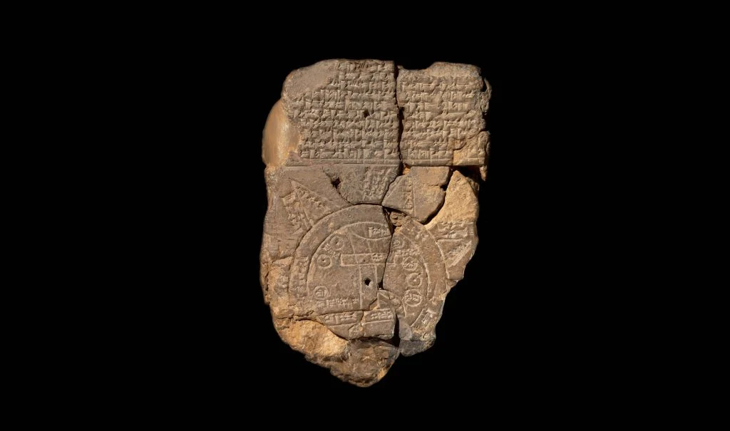
In a groundbreaking discovery, scientists have deciphered what is believed to be the world’s oldest map—a 3,000-year-old Babylonian clay tablet that may reveal the location of Noah’s Ark. The artifact, known as the Imago Mundi, has been housed in the British Museum since 1882 after its discovery in what is now Iraq.
The Biblical Account
According to the Bible, God commanded Noah to build a massive ark to save his family and two of every animal from a devastating flood meant to cleanse the world of wickedness. The flood lasted 150 days, after which the ark came to rest on the “mountains of Ararat.” The Bible specifies the ark’s dimensions as 300 cubits long, 50 cubits wide, and 30 cubits high—approximately 515 feet long, 86 feet wide, and 52 feet high.
The Ancient Tablet’s Secrets
Dr. Irving Finkel, Assistant Keeper of Ancient Mesopotamian script at the British Museum, led the team that unlocked the tablet’s secrets. The Imago Mundi depicts a circular world map showing ancient Mesopotamia at its center, surrounded by a “bitter river” that the Babylonians believed encircled the world.
The tablet’s most intriguing features are found on its reverse side, which contains detailed travel instructions leading to a location called “Urartu”—the Assyrian equivalent of the Biblical “Ararat.” Dr. Finkel explains: “The first place you come to is called ‘Urartu’, it’s drawn on the map. Now, the interesting thing about that is that in the Bible Noah, in his Ark, landed on a mountain where the name is ‘Ararat’ and ‘Ararat’ is the Hebrew equivalent of the Assyrian ‘Urartu’.”
The instructions include specific measurements in “leagues” and references to a “parsiktu-vessel”—a term found in only one other Babylonian tablet, which describes the boat that survived the Great Flood. Dr. Finkel notes, “If you did go on this journey, you would see the remnants of this historic boat which saved all the life of the world for the long-term future.”
Imago Mundi in 2024. Photo: Courtesy of the British Museum.
The Babylonian Connection
The Biblical flood story closely parallels an earlier Babylonian version, where a man named Utnapishtim, rather than Noah, builds the ark at divine command. In the Babylonian account, the god Ea sends the flood, and Utnapishtim’s family and the animals survive by landing at one of Urartu’s peaks.
Modern-Day Evidence
In present-day Turkey, researchers have identified a geological formation known as the Durupinar formation that closely matches the Biblical dimensions of Noah’s Ark. This 538-foot-long formation has attracted significant scientific attention:
- Recent investigations in 2014 and 2019 using ground-penetrating radar revealed “intriguing angular structures” not typically found in natural geological formations
- Scientists from Istanbul Technical University have discovered clay-like substances and marine materials in the soil
- Nearly 30 samples of rock and soil from the site have been dated to between 3,500 and 5,000 years old, aligning with the biblical timeline
- Large amounts of petrified wood have been found inside the formation
Scientific Significance
The Imago Mundi tablet represents one of the most significant archaeological discoveries relating to Biblical narratives. Dr. Nelson Glueck, a renowned archaeologist, has stated that “no archaeological discovery has ever controverted a Biblical reference.” Similarly, Dr. John Ora Kinnaman noted that of the hundreds of thousands of archaeological artifacts discovered, none has contradicted the Bible’s historical accounts.
Ongoing Research
While controversy persists over whether the Durupinar formation is natural or of divine origin, the site continues to attract researchers and tourists. The formation’s location near Mount Tendürek, just 29 kilometers from Mount Ağrı’s peak, makes it a focal point for both scientific investigation and religious interest.
The tablet’s decipherment adds another layer to the ongoing research into one of humanity’s most enduring stories. As Dr. Finkel concludes, “From the Babylonian point of view, this was a matter of fact thing.” The discovery not only provides potential geographical coordinates for Noah’s Ark but also demonstrates the deep historical connections between Babylonian and Biblical narratives.
The British Museum has released a video featuring Dr. Finkel’s detailed explanation of this remarkable discovery, making it accessible to researchers and the public alike. As investigations continue, this ancient map may prove to be a crucial piece in understanding one of history’s most famous accounts of survival and divine intervention.
The post Ancient Babylonian Tablet May Reveal Location of Noah’s Ark appeared first on Israel365 News.
Israel in the News